


Powerful Data  Collection
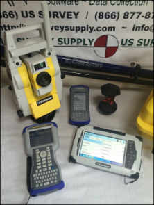
Carlson Software combines advanced functionality, ease-of-use, and sheer capability to make it the first choice in data collection software. Users have the freedom to choose their hardware provider through Carlson Software’s support for a variety of RTK GPS and conventional/robotic Total Stations, new and legacy.
Carlson SurvCE is the first choice in data collection software with advanced, yet easy-to-use functionality:
- Get the software that supports a wide variety of equipment, old or new [Click here to see if your hardware is supported.]
- Enjoy excellent, free (and prompt) technical support
- Be heard – Carlson listens to its customers’ input for new features or drivers for all of its products
SurvCE 5.0 has been released and is now ready for download. Constantly being upgraded, SurvCE 5.0 features many new additions and improvements. Carlson SurvCE 5.0 focuses on speed and power with a new memory allocator, which empowers users to do more, faster.
Top new SurvCE 5.0 features include:
1. “One Touch” points feature selection.
2. Graphical Stakeout Interface based on motion. Two-step stakeout procedure
for navigation and proximity provide a new and original stakeout method that increases productivity and ease-of-use. The new guidance symbols combine well with the e-bubble and other sensor icons to provide intuitive real time information that takes the operator to the point quickly and accurately.
3. Easy-select target feature. Allows user to preconfigure rod heights and targets and switch between them intuitively and easily from all live survey screens.
4. New GNSS mission planning feature computes satellite availability, this includes:
a. Graphics for number of satellites and DOP curves
b. User defined list for obstructions masking.
5. SurvCE LDL (Live Digital Leveling) Full management for IMU sensors in GNSS units. New
features perform accurate and reliable measurements by reducing and compensating for errors due to vertical positioning of the pole.
6. New GNSS antenna library. Fully compatible with NGS-NOAA catalog and now supporting all NGS Absolute and Relative Antennas calibration.
7. Improved memory management to allow bigger user files (dxf-dwg, tin, geoids…).
8. Edit Centerline now has the ability to add curves and spirals by fitting the existing Pls.
9. GPS-Search Improvements for motorized Total Stations – search is quicker and more effective. Provides new distance setting from prism to GPS for better matching and a new more handy icon to perform the search.
10. Extended Point-List format to allow longer points IDs and descriptions with its new binary format that expands the point information.
New SurvCE 4.0 features include:
- Supports full output reporting in GNSS analysis
- GPS base records from the raw file may be processed into the CRD File
- Has full compatibility with the Stewart Weir Software
- Enhanced performance on new capacitive screen data collectors
- Description edit boxes now allow easy access to feature code list
- Field-to-Finish supports creating circles
- Point project automatically creates a customizable output file containing station, offset, and elevation and other user-defined fields
- Supports LandXML Road Model
- Allows GIS storing in any stakeout routine
- Supports text import from drawings
- RW5 file now reads and writes faster
- Supports freehand sketching in the map screen
- Brazil SIRGAS 2000 UTM Zone 18S is now supported
- Supports scalable pixels in background images
- Calculate Area/ Sliding uses a new faster and more robust method
Top features from 3.0 release:
- Ability to stake roads by complete LandXML Road Model—a new method augmenting “By Sections,” “By Templates,” and “From Map”
- Ability to use point “blocks” from drawings as point symbols or as objects to snap to for stakeout or for creating alignments, with GIS attributes associated with blocks recognized;
- Messaging and file transfer office to field or peer-to-peer in field;
- New techniques for best fit smooth curves and tangent curves using Field-to-Finish;
- Use of RTCM 3.1 messages from virtual reference stations to auto-compute grid and geoid shifts.
Easy to use
Tab-Based MENU Structure. All commands are visible in each menu, preventing the need for Up-Down Arrow Keying to view options.
 Enhanced graphics
Collect points in the graphics mode. Points plot as they are shot in the field or entered. There is no need to switch between screens to view your points.
Read in LandXML
Supports LandXML points, DTM, graphics, alignments, profiles and sections.Select Features:
New Look
SurvCE has a colorful look. Icons have been standardized to create continuity throughout the product, while modernizing the user experience.Hot List
The Hot List lets users jump to the SurvCE routines that previously had shortcuts without having to memorize key strokes. It also provides shortcut functionality to devices without keyboards.Volumes
SurvCE can compute volumes between two surfaces, one surface and an elevation or simple stockpile volumes. Surfaces can be defined by graphical entities and points or by Carlson TIN files.Help
The software has optional on-board help files. These files are the entire user manual and can be installed separately. Click on the SurvCE icon and select Help to get the help document that pertains to the current routine.Leveling
SurvCE can be used to collect trigonometric level loops and digital level loops. Loops can be processed and adjusted on the device and all existing project coordinate points can be updated.GPS Networks
SurvCE supports several GPS network protocols, such as NTRIP, TCP and UDP.Localization
The software supports an unlimited number of localization points. All project scale settings and coordinate system options have been centrally located in the localization dialog.Angle Sets in Store Points
SurvCE allows users to “Configure” how each reading is measured with regard to direct and reverse options (Formerly know as SS/Trav). If direct and reverse readings are taken at the backsight, then any direct and reverse foresight will be considered an angle set and will be reduced accordingly. This eliminates the need to use a separate routine for angle sets.Station Equations
SurvCE supports station equations.
Job Settings
- SurvCE has the option to use a template DXF file for new jobs so that all layers and colors are automatically created per your company standard
- It has the option to auto-load cutsheets and control files from the previous job for those users that work on one site continuously
- SurvCE has the ability to turn off the auto-descriptions in stakeout and completely customize how all stakeout routines behave
- Point Number by Interval– SurvCE can interval the point ID by using the “Add to Next Pt ID” option. To number all points on the odd numbers, start at 1 and use 2 in this field.
Feature Coding
- SurvCE can collect parallel lines using the offset horizontal and offset vertical line drawing commands and close a rectangle by three points using the rectangle command. In the settings section of Special Codes, the user can even auto compute and store the additional points at the line vertices that were created by the software.
- SurvCE allows the user to code in numerous coding styles that may be defined by their office package.
Instrument Switching
SurvCE keeps track of every instrument completely separate. This includes all base stations, rovers and total stations, so that mixing equipment is easy. Simply configure your gear once and forget it. The instrument icon has been enhanced to allow you to switch between your current equipment.Skew Angle Staking
SurvCE supports staking offsets on a skew angle and provides the option to stake offset intersections and bisectors at angle points and the radius or PI point of an arc without leaving the Stake Line/Arc routine.
SurvCE Has More
- Supported Instruments
- Supported File Formats
- Supported Handheld Devices


